ROUTE
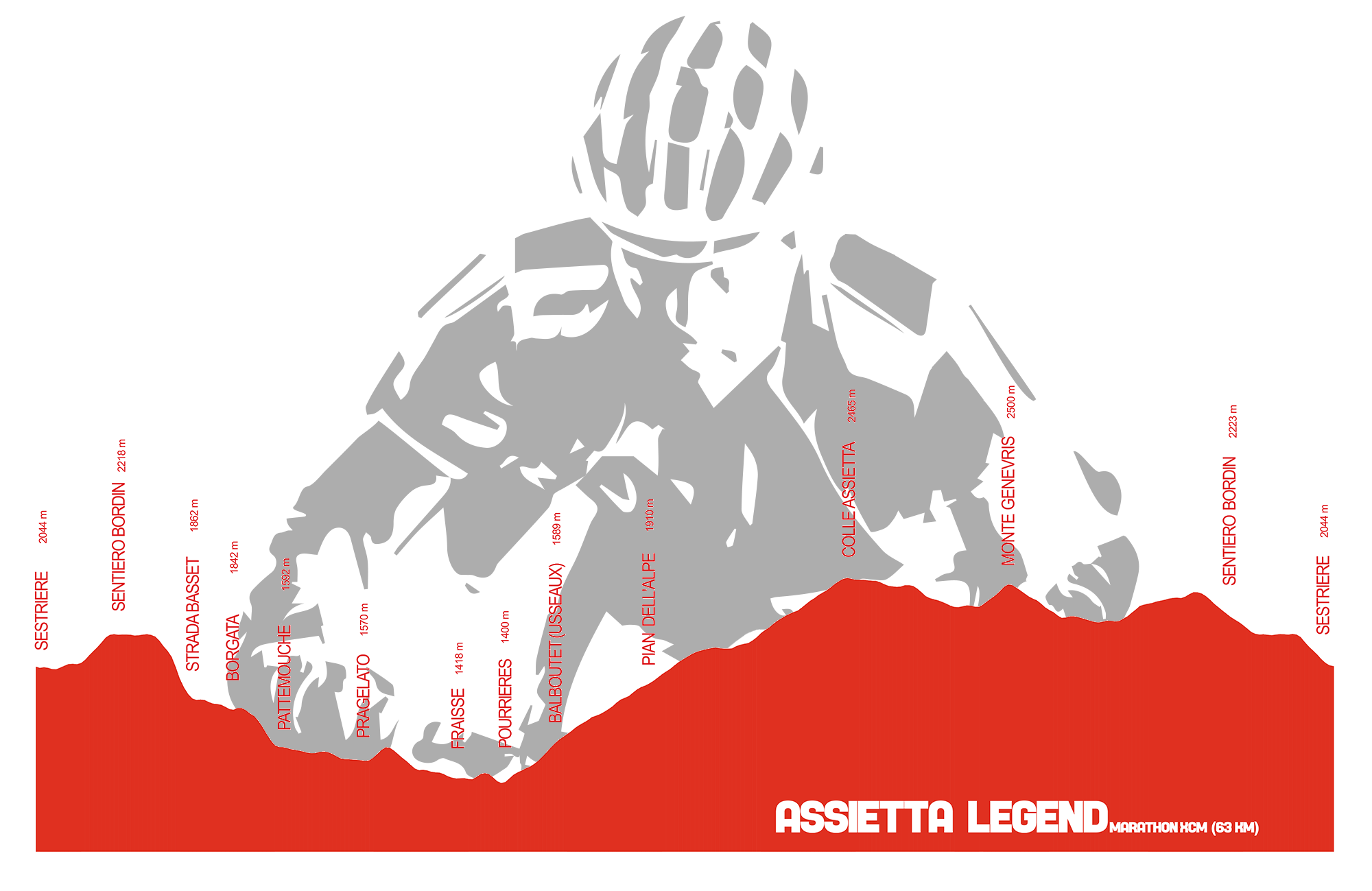
MARATHON LEGEND ROUTE
The race track of Marathon Legend runs along the road of Assietta to over 2,000 meters of altitude in a mountain environment of great beauty, retracing parts of the race track that made famous the Tour dell'Assietta since 1988, to give life to a spectacular, panoramic, hard and fun track.
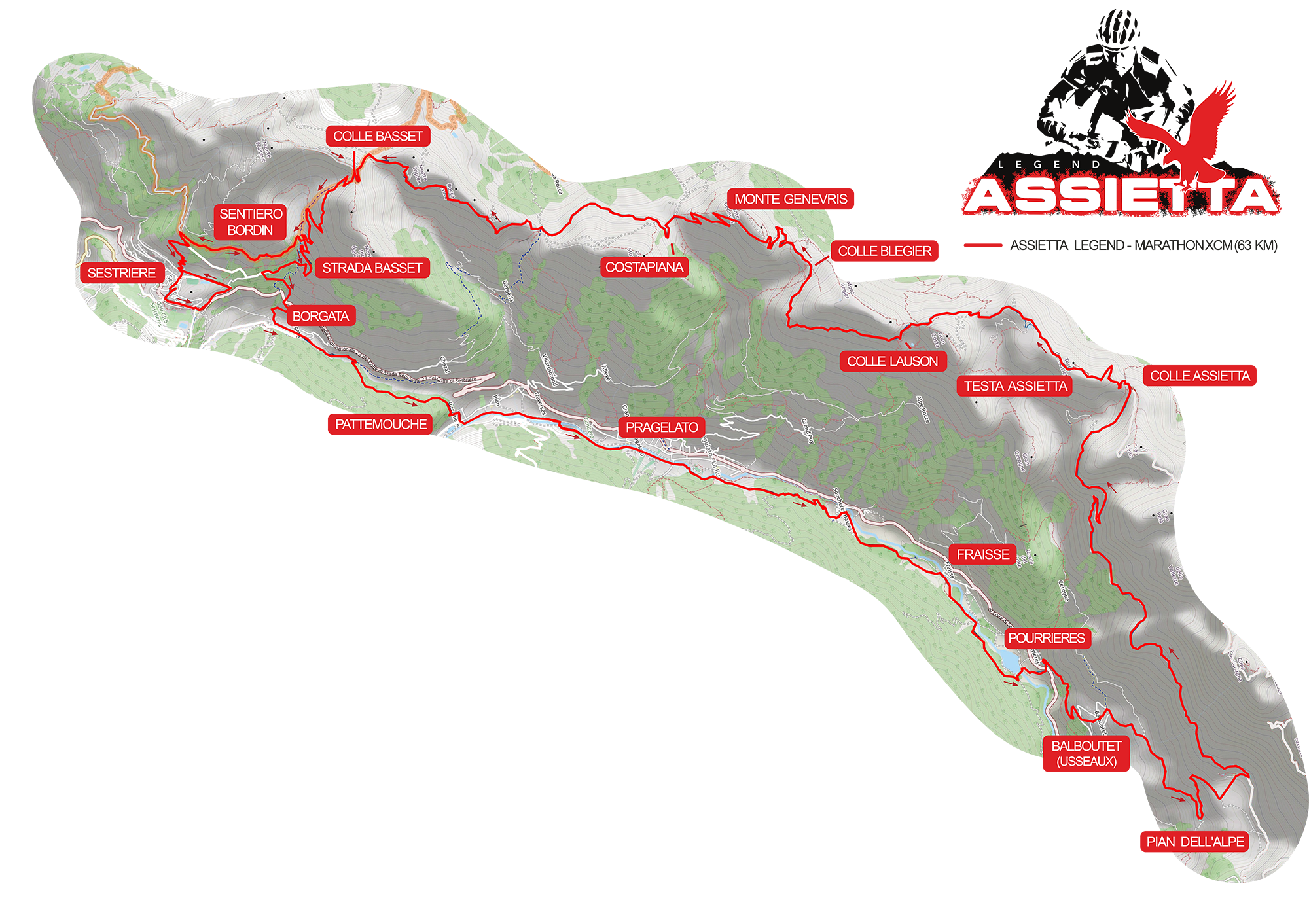
Departure and Finish in Sestriere with a total of 63 Km and D+ 1870 mt.
Departure from Sestriere, a place that does not need any introduction, with the "launch ride" that runs along the highest town in Italy and then take the road that climbs up to “Gelindo Bordin” path (mt. 2218), continuing from here till road of Colle Basset and then towards Sestriere where, almost at the end of the road, take the ski slope that crosses the state road to Pinerolo to continue along the Chisone valley reaching Sestriere Borgata. In a jiffy you reach Pragelato and down to Pourrieres (1418 meters) where you have to turn to Balboutet. Here you start to climb decisively, touching precisely the hamlet of Balboutet (1557 meters) to continue until Pian dell'Alpe location: the dirt road in excellent condition goes up through pastures and coniferous woods reaching the beautiful mountain valley of Pian dell'Alpe, at an altitude of 1821 meters. Continue towards Colle delle Finestre, then turn left onto the strada dell’Assietta (Assietta road) which allows you to admire the splendid panorama towards the valley floor arriving in the last stretch that separates us from the Colle dell’Assietta (2472 m). The view is austere, to say the least superb, and after a short stretch of hard climb you reach the head of the Assietta at an altitude of mt. 2567. From here begins the fast descent that brings us to Col Lauson (2497 meters) and then Col Blegier (2381 meters) which follows the short climb that leads to Monte Genevris (2533 meters), then the descent on the Costa Piana, following Col Bourget (2299 meters) and, at the end of the Assietta road, you reach Col Basset (2424 meters), the last peak of the route from where you descend towards Sestriere. After about 2.5 km of descent, turn on the path "Gelindo Bordin" (2226 m) to go until near the village of Sestriere, where it descends directly to the arrival of Fraiteve square.
ECO ZONE
We respect nature. All participants are required to deposit waste in the eco-zones set up by the organization along the route, which will be supervised in collaboration with local authorities.
Whoever will be caught throwing rubbish out of the pre-established eco-zones will be disqualified from the event with a special announcement from the race direction.
| Feed zone: | Balboutet |
| Pian dell'Alpe | |
| Colle dell'Assietta | |
| Costa Piana | |
| Sestriere (arrival) |